
搜索结果: 1-11 共查到“理学 Digital Elevation Models”相关记录11条 . 查询时间(0.212 秒)
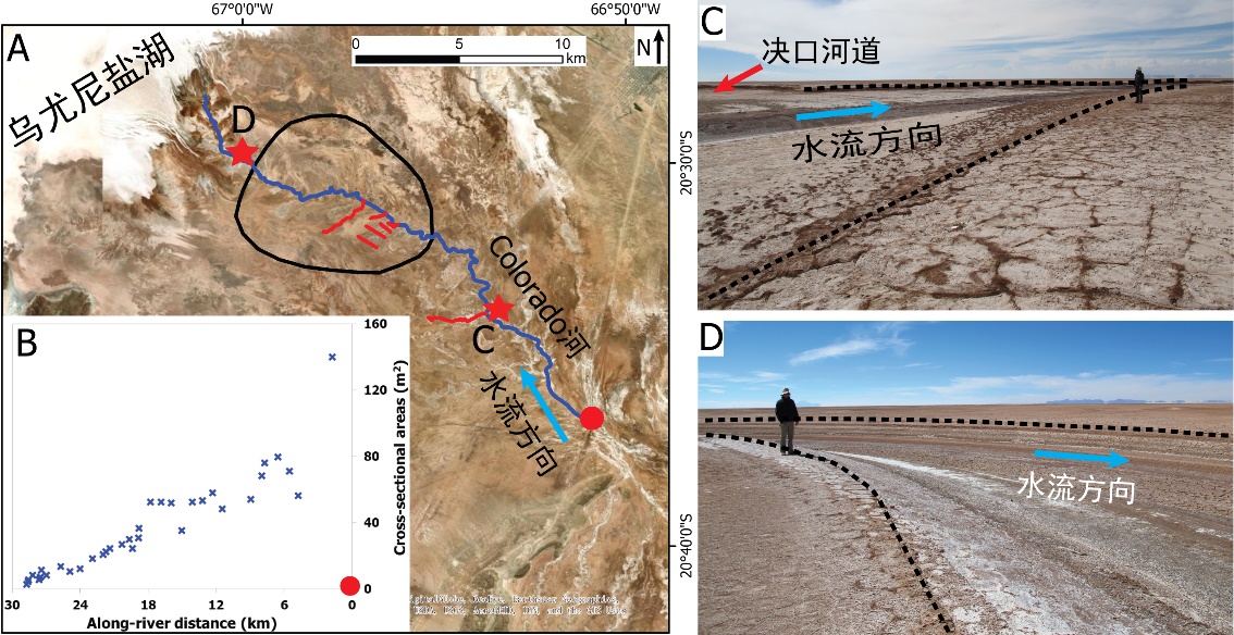
中国地质大学科学技术发展院李嘉光* 等,资源学院. Journal of Hydrology(2020), Digital Elevation Models for topographic characterisation and flood flow modelling along low-gradient, terminal dryland rivers: A comparison of spaceborne datasets for the Río Colorado, Bolivia(图)
精确表征;极低;缓河流;末端;地形;模拟河道;洪水;漫溢
2021/10/15
近日,国际知名期刊Journal of Hydrology在线刊发了中国地质大学资源学院李嘉光副教授团队在陆相湖盆边缘河流末端沉积体系研究的最新成果――Digital Elevation Models for topographic characterisation and flood flow modelling along low-gradient, terminal dryland rive...
Digital elevation models for landslide evolution monitoring: application on two areas located in the Reno River Valley (Italy)
Digital Elevation Model landslide GPS digital photogrammetry laser scanning
2015/9/15
GPS, digital photogrammetry and laser scanning techniques have been applied and compared in the frame of the studies of two complex landslides located in the Emilia-Romagna Region (Northern Italy). Th...
Improving overland flow routing by incorporating ancillary road data into Digital Elevation Models
Watershed Delineation Road Geographic Information System GIS Flow Direction Digital Elevation Model DEM Hydrological Modeling
2015/8/6
Roads, ditches, and culverts influence hydrological and geomorphological processes significantly. However, most hydrological models continue to rely solely on regional digital elevation models (DEMs) ...
Improving overland flow routing by incorporating ancillary road data into Digital Elevation Models
Watershed Delineation Road
2015/1/4
Roads, ditches, and culverts influence hydrological and geomorphological processes significantly. However, most hydrological models continue to rely solely on regional digital elevation models (DEMs) ...
Beach Morphology and Sediment Budget Variability Based on High Quality Digital Elevation Models Derived from Field Data Sets
Moroccan Coast Beach Change Wave Forcing Digital Elevation Model 3-D Approach
2013/3/6
The morphological and volumetric changes of a sandy beach were investigated through a series of two- monthly filed surveys carried out aver a 2-year period from April 2005 to January 2007. This paper ...
Uncertainties associated with digital elevation models for hydrologic applications:a review
Digital elevation models hydrologic applications surface flow
2009/5/12
Digital elevation models (DEMs) represent the topography that drives surface flow and are arguably one of the more important data sources for deriving variables used by numerous hydrologic models. A c...
Computation of area and number frequency dimensions of mountains extracted from multiscale digital elevation models
multiscale digital elevation models (DEMs) mountains lifting scheme
2010/9/15
Frequency dimension is used to characterize fractals that come as distinct individual
objects which are spread over a range of space. In this paper, the number and area
frequency dimensions of mount...
Characterization of catchments extracted from multiscale digital elevation models
multiscale DEMs catchments the lifting scheme
2010/9/15
In this paper, the characterization of catchments extracted from multiscale digital
elevation models (DEMs) is performed. First, the lifting scheme is employed to generate
multiscale DEMs. The catch...
Application of opening by reconstruction to characterize the size distribution of catchments extracted from digital elevation models
reconstruction digital elevation models
2010/9/15
In this paper, concepts of mathematical morphology are employed to characterize the size distributions of catchments extracted from digital elevation models (DEMs). First, opening by reconstruction is...
Abstract?There is a growing interest in investigating the accuracy of digital elevation model (DEM). However people usually have an unbalanced view on DEM errors. They emphasize DEM sampli...
Validation of Digital Elevation Models around Merapi Volcano,Java,Indonesia
Validation Digital Elevation Models Merapi Volcano
2009/12/29
The accuracy of 4 Digital Elevation Models (SRTM30, GTOPO30, SRTM3 and local DEM produced from aerial photogrammetric images) for the volcanoes Merapi and Merbabu in Java, Indonesia is investigated by...