
�������: 1-15 ���鵽����ѧ Exploring����ؼ�¼61�� . ��ѯʱ��(0.109 ��)
Exploring the effects of bound rubber phase on the physical properties of nano-silica composites with a vitrimer-like bond exchangeable matrix
DYNAMIC COVALENT CHEMISTRY CROSS-LINK DENSITY MECHANICAL-PROPERTIES POLYMER NANOCOMPOSITES
2023/11/30
We demonstrate the preparation and unique properties of composite vitrimer-like materials containing silica nanoparticles (SNPs). The matrix is composed of polyacrylate-based polymers crosslinked via ...
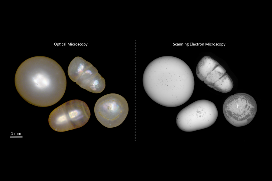
A new research collaboration with The Bahrain Institute for Pearls and Gemstones (DANAT) will seek to develop advanced characterization tools for the analysis of the properties of pearls and to explor...
�Ϻ��ƾ���ѧ��Ϣ�����빤��ѧԺ�����ھ�μ� Exploring Data
�Ϻ��ƾ���ѧ ��Ϣ�����빤��ѧԺ �����ھ� �μ� Exploring Data
2019/7/24
�Ϻ��ƾ���ѧ��Ϣ�����빤��ѧԺ�����ھ�μ� Exploring Data��
EXPLORING SCHEMA MATCHING TO COMPARE GEOSPATIAL STANDARDS: APPLICATION TO UNDERGROUND UTILITY NETWORKS
Schema matching geospatial standard underground utility network
2018/11/9
This paper proposes a preliminary analysis of whether a schema matching approach can be applied for the comparison and possible the selection of geospatial standards. Schema matching is tested in the ...
TESTING THE IMPACT OF 2D GENERALISATION ON 3D MODELS �C EXPLORING ANALYSIS OPTIONS WITH AN OFF-THE-SHELF SOFTWARE PACKAGE
3D generalisation 3D models 3D buildings simplification aggregation performance
2018/11/9
Popularity and diverse use of 3D city models has increased exponentially in the past few years, providing a more realistic impression and understanding of cities. Often, 3D city models are created by ...
EXPLORING CAPABILITIES OF SENTINEL-2 FOR VEGETATION MAPPING USING RANDOM FOREST
Vegetation mapping Sentinel-2 Landsat-8 OLI Random Forest Maximum Likelihood Classifier
2018/5/15
Accurate vegetation mapping is essential for monitoring crop and sustainable agricultural practice. This study aims to explore the capabilities of Sentinel-2 data over Landsat-8 Operational Land Image...
EXPLORING THE APPLICABILITY OF SEMI-GLOBAL MATCHING FOR SAR-OPTICAL STEREOGRAMMETRY OF URBAN SCENES
TerraSAR-X WorldView-2 dense matching semi-global matching (SGM) data fusion SAR-optical stereogrammetry
2018/6/4
Nowadays, a huge archive of data from different satellite sensors is available for diverse objectives. While every new sensor provides data with ever higher resolution and more sophisticated special p...
EXPLORING THE CONNECTIVITY OF ECOLOGICAL CORRIDORS BETWEEN LOW ELEVATION MOUNTAINS AND PINGTUNG LINHOUSILIN FOREST PARK OF TAIWAN BY LEAST-COST PATH METHOD
Linhousilin Forest Park Landscape ecology Least-cost path Gravity model
2016/11/30
The primary purpose of this study was explored the variation of landscape process and its impact on the possibility of ecological corridors on Pingtung Linhousilin Forest Park. Developing the landscap...
EXPLORING REGULARITIES FOR IMPROVING FAÇADE RECONSTRUCTION FROM POINT CLOUDS
Terrestrial LiDAR point clouds Regularities Windows Features Hierarchical clustering ICP Chain
2016/11/11
(Semi)-automatic facade reconstruction from terrestrial LiDAR point clouds is often affected by both quality of point cloud itself and imperfectness of object recognition algorithms. In this paper, we...
EXPLORING THE POTENTIAL OF AERIAL PHOTOGRAMMETRY FOR 3D MODELLING OF HIGH-ALPINE ENVIRONMENTS
Large-format aerial cameras Dense Image Matching Georeferencing ALS Glaciers
2016/3/25
High-alpine areas are subject to rapid topographic changes, mainly caused by natural processes like glacial retreat and other geomorphological processes, and also due to anthropogenic interventions li...
Exploring Semantic Inter-class Relationships (SIR) for Zero-shot Action Recognition
Exploring Semantic Inter-class Relationships Zero-shot Action Recognition
2016/1/22
Automatically recognizing a large number of action cat-egories from videos is of significant importance for video understanding. Most existing works focused on the design of more discriminative featur...
DATA FUSION USING IHS TRANSFORMATIONS FOR EXPLORING ORE DEPOSITS IN NORTHEASTERN PART OF THE SAHARAN METACRATON
Data Fusion IHS Transformations Landsat TM RADARSAT-1 Saharan Metacraton
2015/12/31
The main objective of the remotely sensed data fusion is to create an integrated composite image of improved information and enhanced interpretability. This data have geospatial details about earth��s ...
MODELING THE SPATIAL DISTRIBUTION OF ESHNAN (SEIDLITZIA ROSMARINUS) SHRUBS TO EXPLORING THEIR ECOLOGICAL INTERACTIONS IN DRYLANDS OF CENTRAL IRAN
Eshnan Dryland Modelling Spatial distribution Summary statistic Irano-Turanian zone
2016/1/15
Evaluating the interactions of woody plants has been a major research topic of ecological investigations in arid ecosystems. Plant-plant interactions can shift from positive (facilitation) to negative...
Exploring Space and Time:The Interaction of Transportation and Environment
Dynamic Multitemporal Pollution Environment conceptual data model
2015/12/1
The aim of the study is to explore multi-temporal dimension of interaction between transport, land use and air quality, where the interaction is dynamic and involves changes over spatial and temporal ...
Exploring the Measurement Of Forests With Full Waveform LIDAR through Monte-Carlo Ray Tracing
Forestry structure lidar vegetation simulation 3D modelling satellite
2015/11/20
The error of the height estimates are precisely quantified by comparison with the 3D model height. This paper discusses the development and testing of the inversion of tree height from simulations of ...
�й��о����������а�-��
- ���ڼ���...
�й�ѧ���ڿ����а�-��
- ���ڼ���...
�����ѧ���л������а�-��
- ���ڼ���...
�й���ѧ���а�-��
- ���ڼ���...
�ˡ���-ƪ
- ���ڼ���...
�Ρ���-ƪ
- ���ڼ���...
��������-ƪ
- ���ڼ���...
�������� -ƪ
- ���ڼ���...
֪ʶҪ��-ƪ
- ���ڼ���...
���ʶ�̬-ƪ
- ���ڼ���...
��������-ƪ
- ���ڼ���...
ѧ��ָ��-ƪ
- ���ڼ���...
ѧ��վ��-ƪ
- ���ڼ���...