
�������: 1-15 ���鵽����ѧ assess����ؼ�¼34�� . ��ѯʱ��(0.181 ��)

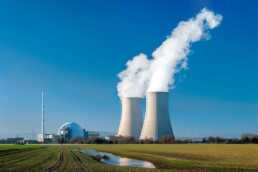
UK begins studies to assess four potential repository sites��ͼ��
�˷��Ϸ��� ���ʴ�����ʩ ���������ϴ���
2023/7/7
Nuclear Waste Services (NWS) is starting the process of evaluating four potential areas for suitability to host the UK's Geological Disposal Facility. It is expected that a final site selection could ...
A new method could greatly reduce the time and expense needed for certain important safety checks in nuclear power reactors. The approach could save money and increase total power output in the short ...
OPTO-TECHNICAL MONITORING �C A STANDARDIZED METHODOLOGY TO ASSESS THE TREATMENT OF HISTORICAL STONE SURFACES
Monitoring Cultural Heritage 3D Scanning UV-VIS-IR photography Preservation Sciences Non-Destructive Testing Methods
2018/6/4
Monitoring is an essential requirement for the planning, assessment and evaluation of conservation measures. It should be based on a standardized and reproducible observation of the historical surface...
REMOTE SENSING TECHNIQUES TO ASSESS POST-FIRE EFFECTS AT THE HILLSLOPE AND SUB-BASIN SCALES VIA MULTI-SCALE MODEL
Multiscale model log-Gaussian Cox processes hillslope micro-topography post-fire environment
2017/7/12
Post-fire environmental footprint is expected at varying scales in space and in time and demands development of multi-scale monitoring approaches. In this paper, a spatially and temporally explicit mu...
AN AUTOMATED GRASS-BASED PROCEDURE TO ASSESS THE GEOMETRICAL ACCURACY OF THE OPENSTREETMAP PARIS ROAD NETWORK
Accuracy FOSS4G GRASS Open data OpenStreetMap Road network Volunteered Geographic Information
2016/11/24
OpenStreetMap (OSM) is the largest spatial database of the world. One of the most frequently occurring geospatial elements within this database is the road network, whose quality is crucial for applic...
APPLICATION OF LiDAR DATE TO ASSESS THE LANDSLIDE SUSCEPTIBILITY MAP USING WEIGHTS OF EVIDENCE METHOD �C AN EXAMPLE FROM PODHALE REGION (SOUTHERN POLAND)
Susceptibility map landslide Weights of Evidence LiDAR Podhale region
2016/7/4
Podhale is a region in southern Poland, which is the northernmost part of the Central Carpathian Mountains. It is characterized by the presence of a large number of landslides that threaten the local ...
USING SATELLITE REMOTE SENSING TO ASSESS EVAPOTRANSPIRATION:CASE STUDY OF THE UPPER EWASO NG��IRO NORTH BASIN, KENYA
SEBAL Actual Evapotranspiration Remote Sensing Landcover/ Landuse NDVI Radiation Energy Balance Heat Fluxes
2016/1/3
Actual Evapotranspiration (ETa) is one of the most useful indicators to explain whether the water is being used as ��intended��. ETa variations, both in space and time and from different land use typesa...
A randomized trial to assess the potential of different beverages to affect hydration status: development of a beverage hydration index
fluid balance dehydration rehydration euhydration electrolytes macronutrients gastric emptying intestinal absorption renal excretion urine
2018/11/28
Background: The identification of beverages that promote longer-term fluid retention and maintenance of fluid balance is of real clinical and practical benefit in situations in which free access to fl...
USING AIRBORNE SMALL-FOOTPRINT LASER SCANNER TO ASSESS THE QUANTITY OF SEEDLINGS IN AN UNEVEN-AGED SPRUCE FOREST
Regeneration uneven-aged forest laser scanner data canopy structure
2015/11/10
The relationships between measures of forest structure as derived from airborne laser scanner data and the variation in quantity of young trees established by natural regeneration in a size-diverse sp...
DEVELOPMENT OF A FRAMEWORK TO ASSESS THE IMPACT OF SCALE DEPENDENT FACTORS ON THE CLASSIFICATION OF LANDCOVER MAPS
Mapping Classification Scale Spatial Resolution Landscape Metric
2015/9/28
Remote sensing data type, classification technique and class description act together to produce, large differences in the classification of landcover. The resulting map will vary in the extent, patch...
3D GIS BASED EVALUATION OF THE AVAILABLE SIGHT DISTANCE TO ASSESS SAFETY OF URBAN ROADS
3D Sight Analysis Sight Distance Road Safety Mobile Mapping Digital Terrain Model Sight Obstruction Low-Cost Sensors GNSS/IMU
2015/9/21
The available sight distance (ASD) in front of the driver to detect possible conflicts with unexpected obstacles is fundamental for traffic safety. In the last 20 years, road design software (RDS) has...
Development of Tools and Techniques to Survey, Assess, Stabilise, Monitor and Preserve Underwater Archaeological Sites: SASMAP
Underwater cultural heritage in situ preservation location
2015/9/11
SASMAP��s purpose is to develop new technologies and best practices in order to locate, assess and manage Europe��s underwater
cultural heritage in a more effective way than is possible today. SASMAP h...
APPLICATION TO MISR LAND BRFS OF THE RPV MODEL INVERSION PACKAGE TO ASSESS ENVIRONMENTAL PATTERNS
RPV model inversion package assess environmental patterns
2015/9/9
The capability of the non-linear Rahman-Pinty-Verstraete (RPV) model to 1) accurately fit a large variety of
Bidirectional Reflectance Factor (BRF) fields and 2) return parameter values of interest f...
APPLICATION OF HIGH-RESOLUTION THERMAL INFRARED REMOTE SENSING TO ASSESS LAND SURFACE TEMPERATURE AND EMISSIVITY IN DIFFERENT NATURAL ENVIRONMENTS
Land surface temperature land surface emissivity thermal infrared
2015/9/8
Airborne thermal infrared image data at high spatial resolution (2-4 m) acquired with the Airborne Hyperspectral Scanner (AHS)
over Barrax (Spain), G�rmin (Germany) and Cabauw, Loobos and Speulderbos ...
REFLECTANCE SPECTROSCOPY IN THE 400-2400 NM TO ASSESS SETTLED DUST IN DIFFERENT URBAN ENVIRONMENTS
Indoor dust loadings Reflectance Spectroscopy Geographical Information System
2015/9/8
The aim of this study was to apply a spectral reflectance approach to account for small amounts of sediment dust in occupied
homes. We examined the method��s ability to predict the gravimetric weight ...
�й��о����������а�-��
- ���ڼ���...
�й�ѧ���ڿ����а�-��
- ���ڼ���...
�����ѧ���л������а�-��
- ���ڼ���...
�й���ѧ���а�-��
- ���ڼ���...
�ˡ���-ƪ
- ���ڼ���...
�Ρ���-ƪ
- ���ڼ���...
��������-ƪ
- ���ڼ���...
�������� -ƪ
- ���ڼ���...
֪ʶҪ��-ƪ
- ���ڼ���...
���ʶ�̬-ƪ
- ���ڼ���...
��������-ƪ
- ���ڼ���...
ѧ��ָ��-ƪ
- ���ڼ���...
ѧ��վ��-ƪ
- ���ڼ���...