
ЫбЫїНсЙћ: 1-15 ЙВВщЕНЁАЩугАВтСПгывЃИаММЪѕ RSЁБЯрЙиМЧТМ26Ьѕ . ВщбЏЪБМф(0.185 Уы)

RSЃКЛљгкЖрдДвЃИаЙлВтЕФЦеШєИкШеБљд1975ЈC2021ФъБљДЈЮяжЪЦНКтгыУцЛ§БфЛЏбаОПЃЈЭМЃЉ
ЖрдДвЃИаЙлВт ЦеШєИкШеБљд 1975ЈC2021Фъ БљДЈЮяжЪЦНКт УцЛ§БфЛЏ
2023/1/16
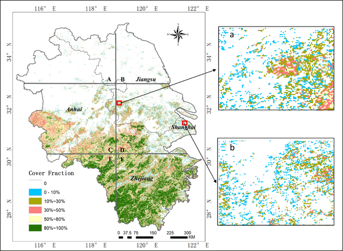
ЧрВиИпдЪЧЪРНчжаЕЭЮГЖШЕиЧјзюДѓЕФБљДЈЧјЃЌЪмЦјКђБфХЏЕФгАЯьЃЌЧрВиИпдДѓВПЗжЕиЧјЕФБљДЈЦеБщМгЫйЭЫЫѕЃЌБљДЈЯрЙиджКІЃЈШчБљБРЁЂБљКўРЃОіЕШЃЉдіЖрЁЃШЛЖјЃЌЧрВиИпдЕФБљДЈБфЛЏЬиеїдкЪБПеГпЖШЩЯОпгаИпЖШвьжЪадЃЌгШЦфЪЧдкИпджаВПЃЌБљДЈЗжВМЯрЖдЯЁЪшЃЌЦфЖдЦјКђБфЛЏЕФЯьгІЛњжЦгаБ№гкЦфЫћЧјгђЁЃвђДЫЃЌЖдЧрВиИпджаВПЕфаЭБљДЈПЊеЙГЄЪБЖЮЁЂЖрЪБЯрЕФЮяжЪЦНКтКЭУцЛ§БфЛЏзлКЯМрВтбаОПЃЌЖдЩюШыСЫНтИУЧјгђБљДЈБфЛЏЧїЪЦМАЦфЖдЦјКђБфЛЏЯьгІЛњжЦЕШОп...
жаЙњЪЏгЭДѓбЇЃЈЛЊЖЋЃЉ2021ФъЫЖЪПбаОПЩњГѕЪдздУќЬтПЦФПGNSSЁЂRSЁЂGISдРэгыЗНЗЈПМЪдДѓИй
жаЙњЪЏгЭДѓбЇЃЈЛЊЖЋЃЉ 2021Фъ ЫЖЪПбаОПЩњ ГѕЪд здУќЬтПЦФП GNSSЁЂRSЁЂGISдРэгыЗНЗЈ ПМЪдДѓИй
2020/10/14
жаЙњЪЏгЭДѓбЇЃЈЛЊЖЋЃЉ2021ФъЫЖЪПбаОПЩњГѕЪдздУќЬтПЦФПGNSSЁЂRSЁЂGISдРэгыЗНЗЈПМЪдДѓИйЁЃ
КгКЃДѓбЇЕиЧђПЦбЇгыЙЄГЬбЇдКВтЛцЯЕВЉЪПЩњбюгЈгЈдквЃИаЖЅМЖЦкПЏISPRS P&RSЗЂБэТлЮФЃЈЭМЃЉ
КгКЃДѓбЇЕиЧђПЦбЇгыЙЄГЬбЇдК ВЉЪПЩњ бюгЈгЈ вЃИаЖЅМЖЦкПЏ ГЃТЬЩСжаХЯЂ
2020/4/14
ЕибЇдКВтЛцЯЕ18МЖВЉЪПЩњбюгЈгЈЭЌбЇТлЮФЁЎFractional evergreen forest cover mapping by MODIS time-series FEVC-CV methods at sub-pixel scalesЁЏБЛвЛЧјЦкПЏ ISPRS Journal of Photogrammetry and Remote SensingНгЪеЗЂБэЃЌЛљгкжаЕШЗжБцТЪвЃИаЪБМфађСаЪ§ОнЪЕЯжСЫДѓГп...
RS-BASED WATER RESOURCES INVENTORY OF THE PHILIPPINES: CAPACITY BUILDING EFFORTS FOR NATIONWIDE IMPLEMENTATION
Capacity Building Hydrologic Data Geodatabase Water Resource Inventory Water Resource Mapping LIDAR
2016/11/15
Considering that the Philippines is archipelagic in nature and is exposed to disasters accentuated by climate change, water resource monitoring and management has been an important concern in the coun...
THE RS IMAGES RESTORATION OF CBERS-2 BASED ON ATMOSPHERIC MTF EVALUATION USING METEOROLOGICAL DATA
Images Restoration RS images Atmospheric MTF Meteorological Data CBERS-2 satellite Turbulence and aerosols
2015/12/28
Atmospheric MTF(Modulation Transfer Function) takes a critical role in restoration of atmospheric blurred RS(Remote Sensing) images. This MTF can be determined by meteorological data. Among the existi...
A STUDY ON THE EXTRACTION OF MULTI-FACTOR INFLUENCING FLOODS FROM RS IMAGE AND GIS DATA;A CASE STUDY IN NACKDONG BASIN,S.KOREA
Spatial Information Sciences Risk Model Terrestrial Photogrammetry Feature Extraction Flood Management Hazard Mapping
2015/12/28
The climate changes will be much more significant over the next 100 years and may lead to the heavy rainfall event. The heavy rainfall causes the flood hazard in the lowlands and geologic hazard in th...
SUSTAINABLE DEVELOPMANT OF FOREST RESOURSE THROUGH RS & GIS TECHNIQUES- A CASE STUDY IN R V NAGAR RANGE, VISAKHAPATNAM DISTRICT, ANDHRA PRADESH
Forest cover change Species Richness Threat Index
2015/8/28
Forest ecosystem is a complex system having interactions with biotic and abiotic components. It includes not only plant and animal
communities but also microorganisms, climate, sunlight, water and so...
The authors are developing educational material package for remote sensing called RS-fun with Macromedia Flash software. RS-fun
is developed under the concept of ЁАedutainmentЁБ(education + entertainm...
Spatial assessment of the change of mountain range farmland use based on rs and gis
Spatial Assessment GIS
2015/8/21
Assessment of the change of farmland use is of great important. After comparing the different ways of the assessment of farmland
use change, a spatial assessment of the change of mountain range farml...
Investigation of the internal structure changes of ulaanbaatar city using rs and gis
Urban internal structure Urban land use CBD
2015/8/20
This paper describes the changes occurred in the internal structure of central part of Ulaanbaatar, the capital city of Mongolia, since
the fall of communism in Mongolia. Currently, Ulaanbaatar is en...
RS-techniques for Land use change detection ЈC Case study of Istanbul
Satellite Imagery Land use change urban dynamics photogrammetry Moland GIS-Analyses Scenarios
2015/7/29
The detection of the Land use change of Istanbul within the last 50 years point out the dramatic change of this city. An
area of more than 3000 km2 was analysed in the MOLAND-Project, where more tha...
LANDUSE RS MONITORING IN CHINA
Remote Sensing land Use Monitoring Change Detection Extraction
2015/7/29
Following rapid development of economy in China, great changes also take place in landuse status, especially in the urban area. In
order to quickly and truly acquire the information of landuse chang...
GIS-goes aerial for RS-data acquisition
Avionic flight-management aerial imaging airborne scanning INS GPS Photogrammetry Planning Controlling
2015/6/1
Powerful modern GIS-components support real-time access to navigation-data in airplanes. This enables to develop sufficient applications for planning and guiding very different projects. GIS component...
THE USING GEOINFORMATIONAL SYSTEM (GIS)AND DATA OF REMOTE SENSING (RS)TO ESTIMATION OF RISING OF LEVEL OF CASPIAN SEA
Caspian Sea Geoinformation System Database Inundated Zone Thematical Map Software
2015/2/4
It is considered the problems of the estimation of dynamics of the change for the shore line of the Caspian Sea from
1977 to 2000 for selected sites of the territory of the Azerbaijan Republic. It is...
жаЙњбаОПЩњНЬг§ХХааАё-Ьѕ
- е§дкМгди...
жаЙњбЇЪѕЦкПЏХХааАё-Ьѕ
- е§дкМгди...
ЪРНчДѓбЇПЦбаЛњЙЙХХааАё-Ьѕ
- е§дкМгди...
жаЙњДѓбЇХХааАё-Ьѕ
- е§дкМгди...
ШЫЁЁЮя-ЦЊ
- е§дкМгди...
ПЮЁЁМў-ЦЊ
- е§дкМгди...
ЪгЬ§зЪСЯ-ЦЊ
- е§дкМгди...
баеазЪСЯ -ЦЊ
- е§дкМгди...
жЊЪЖвЊЮХ-ЦЊ
- е§дкМгди...
ЙњМЪЖЏЬЌ-ЦЊ
- е§дкМгди...
ЛсвщжааФ-ЦЊ
- е§дкМгди...
бЇЪѕжИФЯ-ЦЊ
- е§дкМгди...
бЇЪѕеОЕу-ЦЊ
- е§дкМгди...