
搜索结果: 1-15 共查到“遥感信息工程 Satellite”相关记录284条 . 查询时间(0.109 秒)
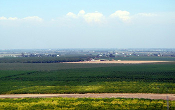
Researchers use satellite imaging to map groundwater use in California's Central Valley(图)
satellite imaging map groundwater California Central Valley
2020/10/16
Researchers at the University of California, San Diego report a new way to improve groundwater monitoring by using a remote sensing technology, known as InSAR (interferometric synthetic aper...
ANALYSIS AND APPLICATION OF LINEAMENTS EXTRACTION USING GF-1 SATELLITE IMAGES IN LOESS COVERED
Geological lineaments Remote Sensing GF-1 satellite images Hough Transform Edge detection
2018/5/14
Faults, folds and other tectonics regions belong to the weak areas of geology, will form linear geomorphology as a result of erosion, which appears as lineaments on the earth surface. Lineaments contr...
AN INSTANTANEOUS POINT SOURCE DETECTION AND EXTRACTION SYSTEM FOR GEO REMOTE SENSING SATELLITE
Instantaneous Point Source FPGA Remote Sensing Image Reconfigurable
2018/5/14
To accomplish the task of detecting the instantaneous point source, an on-board information real-time processing system is designed which can process the point-source detection with reconfigurable fun...
THE BENEFITS AND CHALLENGES OF HAVING AN OPEN AND FREE BASIS SATELLITE DATA SHARING PLATFORM IN TURKEY:GEZGİN
RASAT GEZGIN Satellite data sharing platform
2016/12/1
Turkey is a county that experiences rapid socioeconomic development, which, in turn, leads to high urbanization rates due to migration of people from rural to urban areas, many large-scale development...
IDENTIFYING LOCAL SCALE CLIMATE ZONES OF URBAN HEAT ISLAND FROM HJ-1B SATELLITE DATA USING SELF-ORGANIZING MAPS
Urban heat island Local climate zones Impervious surface area Land surface temperature Surface albedo Self-organization maps
2016/12/1
With the increasing acceleration of urbanization, the degeneration of the environment and the Urban Heat Island (UHI) has attracted more and more attention. Quantitative delineation of UHI has become ...
OBJECT-BASED FOREST COVER MONITORING USING GAOFEN-2 HIGH RESOLUTION SATELLITE IMAGES
Forest Cover Monitoring Segmentation Classification Gaofen-2 High Resolution Satellite Images
2016/12/1
Forest cover monitoring is an important part of forest management in local or regional area. The structure and tones of forest can be identified in high spatial remote sensing images. When forests cov...
CONTRIBUTION OF SATELLITE ALTIMETRY DATA IN GEOLOGICAL STRUCTURE RESEARCH IN THE SOUTH CHINA SEA
South China Sea satellite altimeter data marine gravity data fault system seafloor spreading axis oceanic crust
2016/12/1
The study area is bordered on the East China Sea, the Philippine Sea, and the Australian-Indo plate in the Northeast, in the East and in the South, respectively. It is a large area with the diversely ...
RICE YIELD ESTIMATION THROUGH ASSIMILATING SATELLITE DATA INTO A CROP SIMUMLATION MODEL
Data assimilation remote sensing crop simulation model rice yield
2016/12/1
Rice is globally the most important food crop, feeding approximately half of the world’s population, especially in Asia where around half of the world’s poorest people live. Thus, advanced spatiotempo...
THE ESTIMATE OF THE SPATIAL-TEMPORAL FEATURES OF VEGETATION COVER OF KAZAKHSTAN BASED ON TIME SERIES SATELLITE INDECES IN 2000-2015
remote sensing vegetation indices long-term series trend drought
2016/12/1
The article presents the evaluation of spatial-temporal characteristics of Kazakhstan arid and semi-arid areas' vegetation on the basis of time series of differential and integral vegetation indices. ...
MONITORING LAND USE DYNAMICS OF PERI-URBAN AGRICULTUTRE IN CENTRAL KENYA WITH RAPIDEYE SATELLITE IMAGERY
peri-urban Agriculture Global South sub-saharan Africa urban land use dynamics RapidEye
2016/12/1
The poster submitted to the ISPRS Congress 2016 in Prague illustrates the concept behind the research project in its initial stage. The project concerns recent dynamics of urban and peri-urban agricul...
USING SATELLITE DATA FOR ENVIRONMENTAL IMPACT ANALYSIS IN ECONOMIC GROWTH:THE CASE OF MONGOLIA
Satellite Data Environmental Impact Analysis Economic growth The Green Solow model The Ramsey- Cass- Koopmans model
2016/12/1
The Mongolian economy is based on the primary and secondary economic sectors of agriculture and industry. In addition, minerals and mining become a key sector of its economy. The main mining resources...
MEASUREMENT OF SUN INDUCED CHLOROPHYLL FLUORESCENCE USING HYPERSPECTRAL SATELLITE IMAGERY
Forest stress analysis Hyperspectral Image analysis Sun Induced Chlorophyll Fluorescence Hong Kong Hyperion satellite images Vegetation Indices
2016/12/1
Solar Induced Chlorophyll Fluorescence (SIF), can be used as an indicator of stress in vegetation. Several scientific approaches have been made and there is considerable evidence that steady state Chl...
PRECISION VITICULTURE FROM MULTITEMPORAL,MULTISPECTRAL VERY HIGH RESOLUTION SATELLITE DATA
Vineyards Crop Management Selective Harvesting Oenological potential Phenolic composition
2016/12/1
In order to exploit efficiently very high resolution satellite multispectral data for precision agriculture applications, validated methodologies should be established which link the observed reflecta...
ESTIMATING CARBON STOCK CHANGES OF MANGROVE FORESTS USING SATELLITE IMAGERY AND AIRBORNE LiDAR DATA IN THE SOUTH SUMATRA STATE,INDONESIA
LiDAR Satellite imagery Biomass Carbon stock change Mangrove forest
2016/11/30
The purposes of this study were 1) to estimate the biomass in the mangrove forests using satellite imagery and airborne LiDAR data, and 2) to estimate the amount of carbon stock changes using biomass ...
AUTOMATIC EXTRACTION OF MANGROVE VEGETATION FROM OPTICAL SATELLITE DATA
Mangroves LISS Landsat 8 segmentation pixel value gabor filtering Otsus method
2016/11/30
Mangrove, the intertidal halophytic vegetation, are one of the most significant and diverse ecosystem in the world. They protect the coast from sea erosion and other natural disasters like tsunami and...