搜索结果: 1-15 共查到“Area”相关记录1437条 . 查询时间(0.187 秒)

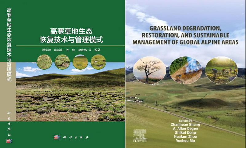
中国科学院西北高原生物研究所《高寒草地生态恢复技术与管理模式》《Grassland Degradation, Restoration and Sustainable Management of Global Alpine Area》出版(图)
生态系统 管理 气候
2025/1/8
高寒草地生态系统作为青藏高原乃至我国生态安全的关键屏障,肩负着水源涵养和补给、生物多样性维持、气候调节以及支撑当地畜牧业生产等重要生态服务功能。然而,2024年来,由于过度放牧、气候变化和不当土地利用等因素的叠加作用,全球高寒草地面临着大规模退化的严峻挑战。这种退化不仅严重威胁到草地生态功能的稳定性,还直接影响到人类和家畜的生存与可持续发展。因此,高寒草地的生态保护与修复,作为一项涉及生态、社会与...
Determinants of changes in harvested area and yields of major crops in China
major crops harvested area Determinants of changes
2024/4/1
Global agricultural production has risen substantially in recent decades and needs to rise further to meet the ever-growing food demand. While higher production can be directly attributed to agri...
Land-Cover and Elevation-Based Mapping of Aboveground Carbon in a Tropical Mixed-Shrub Forest Area in West Java, Indonesia
aboveground biomass geostatistics kriging regression modeling stratification tropical forest
2024/1/23
Carbon sequestration and storage are among the most important ecosystem services provided by tropical forests. Improving the accuracy of the carbon mapping of tropical forests has always been a challe...
Using unmanned aerial vehicle for identifying the vegetative vigor and quantify the area occupied by eucalyptus sprouts after chemical weeding in the state of Bahia, Brazil
Geotechnology Health of plants Precision?forestry Supervised classification
2024/1/12
Currently, the efficiency of chemical weeding for controlling eucalyptus sprouts is measured by field sampling, but the inefficiency of the sampling methods has led to the investigation of new technol...
Using Airborne Lidar, Multispectral Imagery, and Field Inventory Data to Estimate Basal Area, Volume, and Aboveground Biomass in Heterogeneous Mixed Species Forests: A Case Study in Southern Alabama
laser forestry allometry parametric non-parametric modeling 3DEP Alabama
2023/11/30
Airborne light detection and ranging (lidar) has proven to be a useful data source for estimating forest inventory metrics such as basal area (BA), volume, and aboveground biomass (AGB) and for produc...
Trade-Offs and Synergies between Plant Species Diversity and Water Retention Capacity of Pinus massoniana Plantation Community in Danjiangkou Reservoir Area
Pinus massoniana plantation plant species diversity trade-off synergistic ecosystem service Danjiangkou reservoir area
2023/11/22
In order to quantify the plant species diversity characteristics of Pinus massoniana plantations with different stand densities in the Danjiangkou reservoir area of Hubei Province and the relationship...
Using Tree Height, Crown Area and Stand-Level Parameters to Estimate Tree Diameter, Volume, and Biomass of Pinus radiata, Eucalyptus globulus and Eucalyptus nitens
radiata pine blue gum shinning gum diameter-height allometry crown diameter stem volume above-ground biomass growth and yield modeling remote sensing
2023/11/22
Accurate estimates of tree diameter, height, volume, and biomass are important for numerous economic and ecological applications. In this study, we report exponential equations to predict tree DBH (cm...
Effects of Soundscapes on Human Physiology and Psychology in Qianjiangyuan National Park System Pilot Area in China
soundscape national parks human physiology human psychology
2023/11/20
The development of China's national parks is still in the initial stage, and few scholars have studied the effects of soundscapes on human physiology and psychology from the perspective of the auditor...
中国地质大学科学技术发展院叶青(博士研究生),梅廉夫*等 资源学院 构造与油气资源教育部重点实验室 Earth-Science Reviews, Dec 2018, The Late Cretaceous tectonic evolution of the South China Sea area: An overview, and new perspectives from 3D seismic reflection data
南海;北部;陆缘盆地;结构;演化方面
2021/10/20
日前,地球科学Earth-Science Reviews刊发了中国地质大学资源学院和构造与油气资源教育部重点实验室梅廉夫教授团队关于南海北部陆缘盆地结构和演化方面的成果。论文第一单位为构造与油气资源教育部重点实验室,第一作者为博士研究生叶青,通讯作者为梅廉夫教授。
中国地质大学科学技术发展院陈伟涛 等,计算机学院. Remote Sensing(2019), Fine Land Cover Classification in an Open Pit Mining Area Using Optimized Support Vector Machine and WorldView-3 Imagery
地质环境;遥感;智能;解译;研究领域
2021/10/15
近日,中国地质大学计算机学院陈伟涛副教授团队再次在地质环境遥感智能解译研究领域取得重要进展。相关研究成果发表在国际著名期刊《Remote Sensing》(2018年影响因子为4.118)。论文第一作者为陈伟涛副教授,通讯作者为李显巨副教授。

QTL Mapping for Leaf Area of Tea Plants (Camellia sinensis) Based on a High-Quality Genetic Map Constructed by Whole Genome Resequencing
遗传图谱 茶树 QTL 叶面积
2023/4/20
High-quality genetic maps play important roles in QTL mapping and molecular markerassisted breeding. Tea leaves are not only important vegetative organs but are also theorgan for harvest with importan...
Sea-level rise may worsen existing San Francisco Bay Area inequities
sea-level rise community structure climate change
2021/8/3
Researchers examined the number of households unable to pay for damages from coastal flooding to reveal how sea-level rise could threaten the fabric of Bay Area communities over the next 40 years.
New report highlights climate change effects on greater Yellowstone ecosystem:Greater Yellowstone area expected to become warmer, drier
climate change ecosystem warm and dry
2021/8/5
Temperature significantly increased and snowfall decreased in the iconic Greater Yellowstone Area since 1950 because of climate change, and these trends will likely continue through the rest of the ce...
Impacts of forest restoration on soil erosion in the Three Gorges Reservoir area, China
Soil loss Land degradation Ecological restoration Forest landscape restoration The Three Gorges Reservoir area (TGRA)
2024/2/4
Vegetation recovery is a promising strategy to mitigate soil loss risk across different landscapes and human disturbance levels. Uncertainties still exist in the impacts of forest restoration on soil ...


