
�������: 1-15 ���鵽��Drone����ؼ�¼17�� . ��ѯʱ��(0.046 ��)
Estimating Mangrove Tree Biomass and Carbon Content: A Comparison of Forest Inventory Techniques and Drone Imagery
blue carbon allometry unmanned aerial vehicle photogrammetry coastal wetlands
2024/1/22
Mangroves provide many ecosystem services including a considerable capacity to sequester and store large amounts of carbon, both in the sediment and in the above-ground biomass. Assessment of mangrove...
Ensemble machine-learning-based framework for estimating total nitrogen concentration in water using drone-borne hyperspectral imagery of emergent plants: A case study in an arid oasis, NW China
Water resources Remote sensing Total nitrogen Hyperspectral imagery Machine learning Bootstrap
2023/12/19
In arid and semi-arid regions, water-quality problems are crucial to local social demand and human well-being. However, the conventional remote sensing-based direct detection of water quality paramete...
Forest Farm Fire Drone Monitoring System Based on Deep Learning and Unmanned Aerial Vehicle Imagery
Forest Farm Fire Monitoring System Deep Learning
2023/12/1
Forest fires represent one of the main problems threatening forest sustainability. Therefore, an early prevention system of forest fire is urgently needed. To address the problem of forest farm fire m...
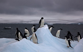
Autonomous multi-drone aerial surveys of Antarctic penguin colonies��ͼ��
Autonomous multi-drone aerial surveys Antarctic penguin colonies
2020/11/13
Scientist Mac Schwager at Stanford University, an aeronautics and astronautics researcher, learned that biologists were seeking a better way to image a large penguin colony in Antarctica. Schwage...
Influence of Drone Altitude, Image Overlap, and Optical Sensor Resolution on Multi-View Reconstruction of Forest Images
UAV drone-based remote sensing geometric image resolution multi-view reconstruction reconstruction efficiency reconstruction quality structure from motion precision forestry
2024/2/4
Recent technical advances in drones make them increasingly relevant and important tools for forest measurements. However, information on how to optimally set flight parameters and choose sensor resolu...
New Opportunities for Forest Remote Sensing Through Ultra-High-Density Drone Lidar
Drone Global Ecosystem Dynamics Investigation (GEDI) Lidar Remote sensing UAV
2024/2/5
Current and planned space missions will produce aboveground biomass density data products at varying spatial resolution. Calibration and validation of these data products is critically dependent on th...
OPTIMIZING RADIOMETRIC PROCESSING AND FEATURE EXTRACTION OF DRONE BASED HYPERSPECTRAL FRAME FORMAT IMAGERY FOR ESTIMATION OF YIELD QUANTITY AND QUALITY OF A GRASS SWARD
Hyperspectral Photogrammetry Calibration Feature Estimation
2018/5/15
Light-weight 2D format hyperspectral imagers operable from unmanned aerial vehicles (UAV) have become common in various remote sensing tasks in recent years. Using these technologies, the area of inte...
REAL-TIME AND POST-PROCESSED GEOREFERENCING FOR HYPERPSPECTRAL DRONE REMOTE SENSING
Photogrammetry Real-time georeferencing drone Hyperspectral frame camera Remote Sensing
2018/6/4
The use of drones and photogrammetric technologies are increasing rapidly in different applications. Currently, drone processing workflow is in most cases based on sequential image acquisition and pos...
CONCEPT MODEL FOR DRONE SELECTION IN SPECIFIC DISASTER CONDITIONS
Drones Disaster Relief Selection Criteria Performance Mapping
2018/4/18
Drones come in huge variety of shapes, sizes and flight characteristics. They can fly in places where no manned aircraft flies or where a person is not desirable to be. Their ability to perform ��3D�� �C...
CONCEPT MODEL FOR DRONE SELECTION IN SPECIFIC DISASTER CONDITIONS
Drones, Disaster Relief, Selection Criteria, Performance Mapping
2018/5/8
Drones come in huge variety of shapes, sizes and flight characteristics. They can fly in places where no manned aircraft flies or where a person is not desirable to be. Their ability to perform ��3D�� �C...
DATA MANAGEMENT FRAMEWORK OF DRONE-BASED 3D MODEL RECONSTRUCTION OF DISASTER SITE
3D Model 3D Reconstruction Disaster Drone Topography Unmanned Aerial Vehicle (UAV)
2016/11/8
To rescue peoples in the disaster site in time, information acquisition of current feature of collapsed buildings and terrain is quite important for disaster site rescue manager. Based on information ...
As flying, camera-bearing drones get smaller and lighter, they increasingly choke on the common ciphers as they interpret their commands, and send back their footage. New paradigm cryptography allows ...
Construction of Sacramento Kings arena using award-winning drone monitoring system developed at Illinois
Sacramento Kings arena drone monitoring system Illinois
2016/3/11
A University of Illinois team has developed predictive visual data analytics tools, called "Flying Superintendent" to automate and streamline today��s time-consuming practices for construction progress...
MICROVEGA (MICRO VESSEL FOR GEODETICS APPLICATION): A MARINE DRONE FOR THE ACQUISITION OF BATHYMETRIC DATA FOR GIS APPLICATIONS
Marine AUSV Open Prototype Morpho - Bathymetric Survey GIS application Bathymetric data interpolation 3D elaboration
2015/4/23
Bathymetric data are fundamental to produce navigational chart and sea-floor 3D models. They can be collected using different techniques and sensors on board of a variety of platforms, such as satelli...
Drone Bombings in the Federally Administered Tribal Areas: Public Remote Sensing Applications for Security Monitoring
Drones Miram Shah Quickbird Remote Sensing US War on Terrorism
2013/3/5
Drone bombing, as a US defense strategy in Pakistan, began under the George W. Bush administration as part of the ��US War on Terrorism�� and has accelerated under the Obama administration. The United S...
�й��о����������а�-��
- ���ڼ���...
�й�ѧ���ڿ����а�-��
- ���ڼ���...
�����ѧ���л������а�-��
- ���ڼ���...
�й���ѧ���а�-��
- ���ڼ���...
�ˡ���-ƪ
- ���ڼ���...
�Ρ���-ƪ
- ���ڼ���...
��������-ƪ
- ���ڼ���...
�������� -ƪ
- ���ڼ���...
֪ʶҪ��-ƪ
- ���ڼ���...
���ʶ�̬-ƪ
- ���ڼ���...
��������-ƪ
- ���ڼ���...
ѧ��ָ��-ƪ
- ���ڼ���...
ѧ��վ��-ƪ
- ���ڼ���...