
搜索结果: 1-15 共查到“ICESat”相关记录16条 . 查询时间(0.218 秒)
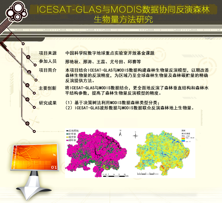
ICESat-GLAS与MODIS数据协同反演森林生物量方法研究(图)

2021年11月30日下午,由山东科技大学研究生会学术科技部主办,测绘与空间信息学院承办的第1034期研究生讲坛在J6楼434报告厅成功举办。测绘与空间信息学院研究生孟文君作了题为“基于ICESat-2卫星激光数据的岛礁周边水深探测研究”的专题讲座,学院相关专业老师和同学参会。
DECOMPOSITION TECHNIQUES FOR ICESAT/GLAS FULL-WAVEFORM DATA
ICESat/GLAS Full-Waveform Waveform Decomposition Method Overlapped Echo Components Levenberg-Marquard (LM) Optimization Method
2018/5/15
The geoscience laser altimeter system (GLAS) on the board Ice, Cloud, and land Elevation Satellite (ICESat), is the first long-duration space borne full-waveform LiDAR for measuring the topography of ...
REMOTE SENSING ANALYSIS OF VOLUME IN TAIHU LAKE: APPLICATION FOR ICESAT/HYDROWEB AND LANDSAT DATA
Taihu Lake Surface area Water level Lake Volume variation Water balance
2018/5/15
In order to evaluate the fluctuation of Taihui Lake, ICESat/Hydroweb and Landsat data recorded from 1975 to 2015 were used to examine changes in lake level and area, derived from Normalized Difference...
VERTICAL ACCURACY ASSESSMENT OF ZY-3 DIGITAL SURFACE MODEL USING ICESAT/GLAS LASER ALTIMETER DATA
Accuracy assessment ZY-3 stereo images DSM ICESat/GLAS
2017/7/12
The Ziyuan-3 (ZY-3) satellite, as the first civilian high resolution surveying and mapping satellite in China, has a very important role in national 1 : 50,000 stereo mapping project. High...
ANTARCTIC ICE SHEET SURFACE MASS BALANCE ESTIMATES FROM 2003 TO 2015 USING ICESAT AND CRYOSAT-2 DATA
Antarctica Mass Balance ICESat CryoSat-2
2016/11/30
An assessment of Antarctic ice sheet surface mass balance from 2003 to 2015 has been carried out using a combination of ICESat data from 2003 to 2009 and CryoSat-2 data from 2010 to 2015. Both data se...
ESTIMATION OF REGIONAL FOREST ABOVEGROUND BIOMASS COMBINING ICESAT-GLAS WAVEFORMS AND HJ-1A/HSI HYPERSPECTRAL IMAGERIES
LiDAR ICESat-GLAS Waveform HJ-1A/HSI Hyperspectral imagery Forest aboveground biomass Support vector machines
2016/11/24
Estimation of forest aboveground biomass (AGB) is a critical challenge for understanding the global carbon cycle because it dominates the dynamics of the terrestrial carbon cycle. Light Detection and ...
ICESAT VALIDATION OF TANDEM-X I-DEMS OVER THE UK
Global DEM validation TanDEM-X intermediate DEM ICESat elevations
2016/11/8
From the latest TanDEM-X mission (bistatic X-Band interferometric SAR), globally consistent Digital Elevation Model (DEM) will be available from 2017, but their accuracy has not yet been fully charact...
EVALUATION OF ASTER GDEM V3 USING ICESAT LASER ALTIMETRY
ASTER ICESat Topography Elevation Models Geodetic Ground Control Laser Altimetry
2016/11/8
We have used a set of Ground Control Points (GCPs) derived from altimetry measurements from the Ice, Cloud and land Elevation Satellite (ICESat) to evaluate the quality of the 30 m posting ASTER (Adva...
IMPROVE THE ZY-3 HEIGHT ACCURACY USING ICESAT/GLAS LASER ALTIMETER DATA
ZY-3 ICESat GLAS Satellite Laser Altimetry Satellite LiDAR
2016/7/4
ZY-3 is the first civilian high resolution stereo mapping satellite, which has been launched on 9th, Jan, 2012. The aim of ZY-3 satellite is to obtain high resolution stereo images and support the 1:5...
TEMPERATE FOREST HEIGHT ESTIMATION PERFORMANCE USING ICESAT GLAS DATA FROM DIFFERENT OBSERVATION PERIODS
Temperate Forest Height Large Footprint Lidar waveform ICEsat GLAS Observation Period
2015/12/31
To investigate the forest height estimation potential and performance of different observation periods GLAS data in temperate region, this study uses the Northeast of China as test site. USFS FIA styl...
ICESAT FULL WAVEFORM ALTIMETRY COMPARED TO AIRBORNE LASER ALTIMETRY OVER THE NETHERLANDS
Full waveform DTM AHN Laser altimetry ICESat
2015/11/10
Since 2003 the spaceborne laser altimetry system on board of NASA’s Ice, Cloud and land Elevation Satellite (ICESat) has acquired a large world-wide database of full waveform data organized in 15 prod...
Vegetation height and cover fraction between 60° S and 60° N from ICESat GLAS data
Vegetation height cover fraction 60° S and 60° N ICESat GLAS data
2014/12/11
We present new coarse resolution (0.5° × 0.5°) vegetation height and vegetation-cover fraction data sets between 60° S and 60° N for use in climate models and ecological models. The data sets are deri...
基于ICESat轨道交叉点分析的东南极Lambert-Amery系统当前高程变化特征分析
Lambert-Amery System(LAS) 高程变化 ICESat/GLAS 交叉点分析
2011/11/11
南极冰盖物质平衡仍然是全球海平面变化估计的最大不确定因素.本文使用2003~2007年ICESat/GLAS获取的高精度冰盖测高数据,利用我们开发的高精度高程变化提取程序,首次获取了东南极最大冰流系统――Lambert-Amery地区在ICESat卫星轨道交叉点处的高程变化序列.依据冰川动力学原理,对该流域进行详细划分,并在此基础上利用回归模型研究各子区域内高程年际变化特征.对该区域的研究有以下新...