搜索结果: 1-15 共查到“Sentinel-2”相关记录85条 . 查询时间(0.062 秒)
Optimal Input Features for Tree Species Classification in Central Europe Based on Multi-Temporal Sentinel-2 Data
tree species classification Sentinel-2 multi-temporal Wienerwald biosphere reserve
2024/1/23
Detailed knowledge about tree species composition is of great importance for?forest?management. The two identical European Space Agency (ESA) Sentinel-2 (S2) satellites provide data with unprecedented...
Estimating aboveground biomass of the mangrove forests on northeast Hainan Island in China using an upscaling method from field plots, UAV-LiDAR data and Sentinel-2 imagery
Mangroves Aboveground biomass UAV-LiDAR Sentinel-2 Random forest
2024/1/23
The mangrove forests of northeast Hainan Island are the most species diverse forests in China and consist of the Dongzhai National Nature Reserve and the Qinglan Provincial Nature Reserve. The former ...
Modelling above-ground biomass stock over Norway using national forest inventory data with ArcticDEM and Sentinel-2 data
Space-borne imagery Stereogrammetry Boreal forest structure Biomass mapping Open data
2024/1/22
Boreal forests constitute a large portion of the global forest area, yet they are undersampled through field surveys, and only a few remotely sensed data sources provide structural information wall-to...
Analysis of Regional Distribution of Tree Species Using Multi-Seasonal Sentinel-1&2 Imagery within Google Earth Engine
multisensor tree species large areas cloud-computing machine learning
2023/12/6
Accurate information on tree species is in high demand for forestry management and further investigations on biodiversity and environmental monitoring. Over regional or large areas, distinguishing tre...
The Utility of Sentinel-2 Spectral Data in Quantifying Above-Ground Carbon Stock in an Urban Reforested Landscape
reforestation ecosystem services carbon stock random forest
2023/12/5
The transformation of the natural landscape into an impervious surface due to urbanization has often been considered an important driver of environmental change, affecting essential urban ecological p...
Identification of Urban Green Space Types and Estimation of Above-Ground Biomass Using Sentinel-1 and Sentinel-2 Data
urban green space above-ground biomass classification Sentinel-2 Sentinel-1
2023/12/1
High-quality urban green space supports the healthy functioning of urban ecosystems. This study aimed to rapidly assess the distribution, and accurately estimate the above-ground biomass, of urban gre...
Potential of Convolutional Neural Networks for Forest Mapping Using Sentinel-1 Interferometric Short Time Series
Synthetic Aperture Radar Sentinel-1 forest mapping deforestation monitoring deep learning convolutional neural networks
2023/12/1
The monitoring of land cover and land use patterns is pivotal in the joint effort to fight deforestation in the Amazon and study its relation to climate change effects with respect to anthropogenic ac...

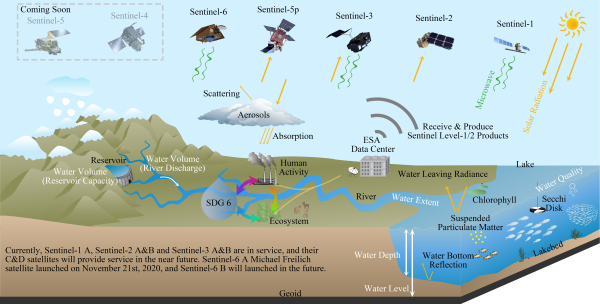
地表水体是地球表层系统各圈层相互作用的关键联结点,对社会经济发展、区域气候调节、生态系统平衡、生物多样性保护具有重要意义。随着卫星传感技术的飞速发展和地表水动态变化监测的需求增加,遥感在水体监测方面显现了巨大优势和潜力,同时也伴随一定的局限和挑战。在轨可用的卫星传感器性能各异,却很少能同时满足地表水体多尺度、多要素、多维度的监测需求。整合多类卫星传感器,构建虚拟卫星星座的遥感观测体系,能够兼顾水体...

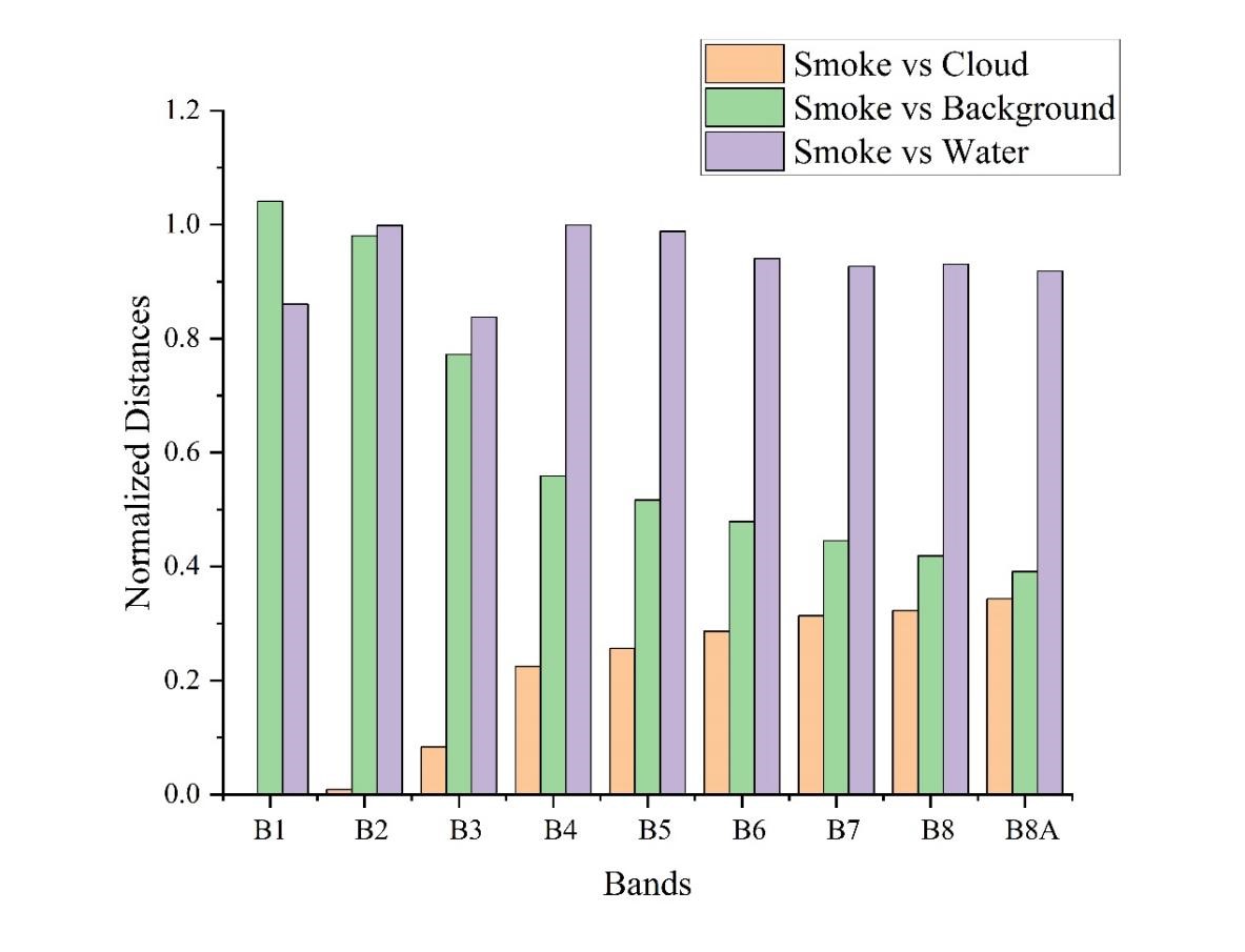
中国东北农村地区,春秋季节由于秸秆的大量焚烧,大气悬浮颗粒物含量明显升高,PM10和PM2.5可以升高0.5至4倍。露天生物质燃烧(Open-air biomass burning,OBB)是微量气体污染物和细小碳质颗粒物(particulate matter,PM)的主要排放源。大面积、高强度的露天焚烧秸秆会对区域的空气质量以及当地的公共卫生安全造成损害。秸秆燃烧检测主要是靠检测秸秆焚烧的产物来...

RSE: 基于理论散射模型的区域尺度Sentinel-1A卫星观测模拟与半经验水云模型标定方法研究(图)
理论散射模型 区域尺度 Sentinel-1A卫星观测模拟 半经验水云模型标定方法
2023/1/16

多时相InSAR技术具有探测大范围毫米级地表形变的能力,已被广泛应用于地面沉降监测。近几年,应用多时相InSAR技术监测以高铁为代表的大尺度人造线状地物形变备受关注。本文将C波段SAR数据用于高铁沿线路基形变监测,应用相位稳定性分析和改进的StaMPS技术来增加相干性点的密度和形变参数解算的稳定性。采用研究区时间跨度为21个月的47景Sentinel-1A数据,对连(云港)盐(城)高铁及其沿线区域...
基于Sentinel-1A微波遥感数据的森林蓄积量估测
Sentinel-1A 森林蓄积量 微波遥感数据 纹理特征 随机森林法 偏最小二乘法 估测
2021/7/13
Sentinel-1A作为开源的集微波和光学数据一体的卫星数据源,给森林资源调查和监测提供了重要的数据源。为了探索Sentinel-1A数据在森林资源调查中的可用性,以Sentinel-1A为遥感数据源,结合地面样地森林蓄积量调查数据,采用随机森林法和偏最小二乘法两种模型对云南省普洱市思茅区的森林蓄积量进行预测以及遥感反演。通过对遥感影像进行一系列预处理,提取微波遥感数据VV和VH极化下的后向散射...
时序Sentinel-1TOPS模式SAR数据精配准
TOPS 配准 相干性 Sentinel-1 SAR 增强谱分集
2021/6/30
Sentinel-1卫星星座采用TOPS作为默认成像模式,要求方位向配准精度达到0.001像素以便确保相邻burst干涉图的相位偏差小于3°。ESD技术是消除几何配准系统误差、纠正方位向配准偏移量的有效方法,但在低相干性场景或快速去相关的条件下,该方法配准精度会随着相干的降低而衰减,并导致配准误差的传播,造成干涉图出现相位跳变。为解决这一问题,本文提出一种TOPS模式数据时间序列配准方法。该方法在...


