
搜索结果: 1-15 共查到“地球物理学 Information”相关记录21条 . 查询时间(0.054 秒)
GLOBAL REGISTRATION OF KINECT POINT CLOUDS USING AUGMENTED EXTENDED INFORMATION FILTER AND MULTIPLE FEATURES
Global registration Kinect Augmented extended Information filter Point cloud fitting Indoor mapping
2016/10/14
Because the Infra-Red (IR) Kinect sensor only provides accurate depths up to 5 m for a limited field of view (60°), the problem of registration error accumulation becomes inevitable in indoor ma...
3D SURVEYING, MODELING AND GEO-INFORMATION SYSTEM OF THE NEW CAMPUS OF ITB-INDONESIA
UAV Photogrammetry Laser Scanner BIM 3D GIS CityGML IFC
2016/10/14
The new campus of ITB-Indonesia, which is located at Jatinangor, requires good facilities and infrastructures to supporting all of campus activities. Those can not be separated from procurement and ma...
3D GEO-INFORMATION IN URBAN CLIMATE STUDIES
3D geo-information Urban climate Urban planning Urban climate characteristics Numerical models
2016/10/14
3D geo-information is essential for urban climate studies. It is obvious that both natural environment and built-up environment play the fundamental role in defining the climatic conditions for urban ...
APPROACH AND EVALUATION OF A MOBILE VIDEO-BASED AND LOCATION-BASED AUGMENTED REALITY PLATFORM FOR INFORMATION BROKERAGE
Augmented Reality Image tracking Edutainment ARML GPS Beacons Gamification User Experience
2016/10/14
Providing mobile location-based information for pedestrians faces many challenges. On one hand the accuracy of localisation indoors and outdoors is restricted due to technical limitations of GPS and B...
Tornillo seismic events at Galeras volcano, Colombia: a summary and new information from broadband three-component measurements
volcanoes seismic events broadband record tornillos Galeras volcano
2015/10/8
Long-duration events have been recorded at several active, andesitic volcanoes. Their main characteristics are a single, sharp frequency peak, and an exceptionally long coda. Because their seismograms...
Deriving numerical estimates from descriptive information: the computation of earthquake parameters
macroseismic epicenter epicentral intensity macroseismic magnitude
2015/9/30
We describe here how the origin time, the epicenter location, the epicentral intensity and the magnitude of the earthquakes included in the Catalogue of Strong Italian Earthquakes (CFTI3) have been de...
Information on subsoil geological structure in the city of Catania (Eastern Sicily) from microtremor measurements
microtremors H/V technique sire response subsoil geological structure
2015/9/28
Nakamuras technique, or the H/V spectral ratio method, has been applied to microtremor measurements carried out in the urban area of Catania (Eastern Sicily) to obtain information on the geological st...
Information technology tools for the valorisation of seismology’s historical documentary heritage
technology tools historical documentary heritage
2015/8/28
In the past few decades historical documentation of a scientific and non-scientific nature has taken on critical
importance in the different sectors of seismology: historical seismology and historica...
On the use of the Internet to collect earthquake information
Internet earthquake information
2015/8/27
As geophysicists, we find it difficult to imagine our daily professional and personal lives without the Internet. Emails have been the mainstay of scientific communication since the 1980’s and website...
An ethical approach to socio-economic information sources in ongoing vulnerability and resilience studies: the Mount Cameroon case
Vulnerability Resilience Social recovery Mount Cameroon MIA-VITA Project
2015/8/26
The study of the vulnerability of facing natural and man-made hazards, with the related resilient answers belong to the complex and articulate field of social sciences called ‘Disaster Anthropology’. ...
Turning the rumor of the May 11, 2011, earthquake prediction in Rome, Italy, into an information day on earthquake hazard
Seismic hazard Education and outreach Seismic risk reduction
2015/8/26
A devastating earthquake was predicted to hit Rome on May 11, 2011. This prediction was never officially released, but it grew on the internet and was amplified by the media. It was erroneously ascrib...
The INGVterremoti blog:a new communication tool to improve earthquake information during the Po Plain seismic sequence
Seismology Educational Public issues Earthquakes Seismic awareness Seismic hazard
2015/8/26
During a seismic sequence, it is extremely important that the population shaken by the earthquakes has continuous and timely information about the ongoing seismic activity. For this reason, a few days...
Pull vs. Push: How OmniEarth Delivers Better Earth Observation Information to Subscribers
Constellation-Measurements Geoinformatics
2015/5/7
Until very recently, the commercialization of Earth observation systems has largely occurred in two ways: either through the detuning of government satellites or the repurposing of NASA (or other sci...
Multi-criteria site selection for fire services: the interaction with analytic hierarchy process and geographic information systems
Multi-criteria site selection fire services the interaction analytic hierarchy process geographic information systems
2010/10/21
This study combines AHP and GIS to provide decision makers with a model to ensure optimal site location(s) for fire stations selected. The roles of AHP and GIS in determining optimal locations are exp...
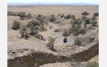
New Earthquake Information Unearthed by San Andreas Fault Studies(图)
New Earthquake Information San Andreas Fault Studies
2010/1/22
Recent studies of stream channel offsets along the San Andreas Fault reveal new information about fault behavior--changing our understanding of the potential for damaging earthquakes.
The studies wer...