
�������: 1-15 ���鵽������ѧ���� Earth����ؼ�¼100�� . ��ѯʱ��(0.036 ��)

���ӿƼ���ѧ��Դ�뻷��ѧԺ����ң���Ŷ��ڡ�Earth System Science Data�������о��ɹ���ͼ��
����ң�� �����ѧ ���� �Ⱥ��� ң�в�������
2020/12/18
���գ���У�ʻ�ѧԺ����ң���Ŷ��������Ⱥ���ң�в������ݷ���ȡ����Ҫ�о���չ�������ڵ����ѧ�����ڿ���Earth System Science Data����һ���ڿ���Ӱ������9.197����������Ϊ��A global long-term (1981�C2000) land surface temperature product for NOAA AVHRR����ѧ�����ġ�2017����ʿ������Ϊ���ĵ�һ...
���ϴ�ѧ���ı�����ڵ�ѧȨ���ڿ���JGR: Solid Earth�����������о��ɹ���ͼ��
���ϴ�ѧ ���ı� ���� ��ѧ �����״� ��������
2020/9/18
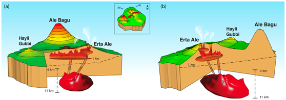
���գ���У�����ѧ����Ϣ����ѧԺ-�״�ң��ʵ����-��ɽ������о����������ı�������εĿ�ѧ���о��Ŷ��ڵ�ѧ������ʵ�ѧȨ���ڿ�����Ȼָ���ڿ���NI68��֮һ�ġ�Journal of Geophysical Research: Solid Earth����������Ϊ��Volcano�\Wide Deformation After the 2017 Erta Ale Dike Intrusion, Ethi...
OPEN FORIS AND GOOGLE EARTH ENGINE LINKING EXPERT PARTICIPATION WITH NATURAL RESOURCE MAPPING AND REMOTE SENSING TRAINING IN TANZANIA
Open source earth observation remote sensing geospatial cloud computing crowdsourcing training Tanzania
2018/11/8
There is an increasing amount of open Earth observation (EO) data available, offering solutions to map, assess and monitor natural resources and to obtain answers to global and local societal challeng...
FREE GLOBAL DSM ASSESSMENT ON LARGE SCALE AREAS EXPLOITING THE POTENTIALITIES OF THE INNOVATIVE GOOGLE EARTH ENGINE PLATFORM
DSM assessment Google Earth Engine ASTER SRTM geometric accuracy
2017/7/13
The high-performance cloud-computing platform Google Earth Engine has been developed for global-scale analysis based on the Earth observation data. In particular, in this work, the geometric accuracy ...
2017SPIE������Դ�뻷��ң��/GISӦ��ר����飨Earth Resources and Environmental Remote Sensing/GIS Applications��
2017 SPIE ������Դ�뻷��ң��/GISӦ�� ר�����
2017/4/26
Satellite remote sensing has become a common tool to investigate the different fields of Earth and environmental sciences. The progress of the performance capabilities of the optoelectronic and radar ...
EARTH OBSERVATION-SUPPORTED SERVICE PLATFORM FOR THE DEVELOPMENT AND PROVISION OF THEMATIC INFORMATION ON THE BUILT ENVIRONMENT�CTHE TEP-URBAN PROJECT
Service platform participatory urban monitoring earth observation decision support
2016/12/1
The Sentinel fleet will provide a so-far unique coverage with Earth observation data and therewith new opportunities for the implementation of methodologies to generate innovative geo-information prod...
DESIGN OF A FREE AND OPEN SOURCE DATA PROCESSING,ARCHIVING,AND DISTRIBUTION SUBSYSTEM FOR THE GROUND RECEIVING STATION OF THE PHILIPPINE SCIENTIFIC EARTH OBSERVATION MICRO-SATELLITE
Micro-satellite Data Processing Open Source Software System Design
2016/11/24
The Philippines��s PHL-Microsat program aims to launch its first earth observation satellite, DIWATA, on the first quarter of 2016. DIWATA��s payload consists of a high-precision telescope (HPT), spaceb...
SUPPORTING MANAGEMENT OF EUROPEAN REFUGEE STREAMS BY EARTH OBSERVATION AND GEOINFORMATION
Refugee streams Data Mining Earth Observation Detecting habitation reserves
2016/11/24
The sharp increase in refugee numbers arriving in the European Union has recently caused major and manifold challenges for the member states and their administrative services. Location based situation...
ALGORITHMS FOR RELATIVE RADIOMETRIC CORRECTION IN EARTH OBSERVING SYSTEMS ��RESOURCE-P�� AND ��CANOPUS-V��
Pushbroom And Matrix Imagery Instruments Relative Radiometric Correction Reference Calibration Images
2016/11/15
The present paper has considered two algorithms of the relative radiometric correction of information obtained from a multimatrix imagery instrument of the spacecraft ��Resource-P�� and frame imagery sy...
BRIDGING THE GAP BETWEEN NASA EARTH OBSERVATIONS AND DECISION MAKERS THROUGH THE NASA DEVELOP NATIONAL PROGRAM
NASA DEVELOP National Program Applied Science Earth Observations Decision Making Process
2016/11/15
The NASA DEVELOP National Program bridges the gap between NASA Earth Science and society by building capacity in both participants and partner organizations that collaborate to conduct projects. These...
THE DESIGN OF A HIGH PERFORMANCE EARTH IMAGERY AND RASTER DATA MANAGEMENT AND PROCESSING PLATFORM
Raster Database Image Processing Raster Analytics HPC Oracle GeoRaster Platform
2016/11/8
This paper summarizes the general requirements and specific characteristics of both geospatial raster database management system and raster data processing platform from a domain-specific perspective ...
The near-global elevation product from NASA��s Shuttle Radar Topographic Mission (SRTM) has been widely used since its release in 2005 at 3 arcsecond resolution and the release of the 1 arcsecond versi...
Earth Resources and Environmental Remote Sensing/GIS Applications
Earth Resources Environmental Remote Sensing
2016/7/28
Long range land surveillance is a critical need in numerous military and civilian security applications, such as threat detection, terrain mapping and disaster prevention. A key technology for land su...
BARE-EARTH EXTRACTION AND DTM GENERATION FROM PHOTOGRAMMETRIC POINT CLOUDS WITH A PARTIAL USE OF AN EXISTING LOWER RESOLUTION DTM
Photogrammetry Point cloud DSM DTM Ground filtering Image matching
2016/7/27
A method of extracting bare-earth points from photogrammetric point clouds by partially using an existing lower resolution digital terrain model (DTM) is presented. The bare-earth points are extracted...
Earth observation systems/sensors for meeting sustainable development needs
Earth observation systems/sensors sustainable development needs
2016/5/20
Earth observation satellites were among the earliest space launches and were originally exploited
for military and weather programs. Operational civil remote sensing was initiated in 1972 by the
Lan...
�й��о����������а�-��
- ���ڼ���...
�й�ѧ���ڿ����а�-��
- ���ڼ���...
�����ѧ���л������а�-��
- ���ڼ���...
�й���ѧ���а�-��
- ���ڼ���...
�ˡ���-ƪ
- ���ڼ���...
�Ρ���-ƪ
- ���ڼ���...
��������-ƪ
- ���ڼ���...
�������� -ƪ
- ���ڼ���...
֪ʶҪ��-ƪ
- ���ڼ���...
���ʶ�̬-ƪ
- ���ڼ���...
��������-ƪ
- ���ڼ���...
ѧ��ָ��-ƪ
- ���ڼ���...
ѧ��վ��-ƪ
- ���ڼ���...