
�������: 1-15 ���鵽������ѧ���� Solid����ؼ�¼15�� . ��ѯʱ��(0.031 ��)
���ϴ�ѧ���ı�����ڵ�ѧȨ���ڿ���JGR: Solid Earth�����������о��ɹ���ͼ��
���ϴ�ѧ ���ı� ���� ��ѧ �����״� ��������
2020/9/18
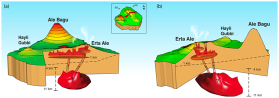
���գ���У�����ѧ����Ϣ����ѧԺ-�״�ң��ʵ����-��ɽ������о����������ı�������εĿ�ѧ���о��Ŷ��ڵ�ѧ������ʵ�ѧȨ���ڿ�����Ȼָ���ڿ���NI68��֮һ�ġ�Journal of Geophysical Research: Solid Earth����������Ϊ��Volcano�\Wide Deformation After the 2017 Erta Ale Dike Intrusion, Ethi...
GENERATION AND COMPARISON OF TLS AND SFM BASED 3D MODELS OF SOLID SHAPES IN HYDROMECHANIC RESEARCH
Terrestrial Laser Scanning Structure-from-Motion 3D Model Volume Calculation Hydromechanics
2016/11/11
The aim of a current study at the Institute of Hydraulic Engineering and Technical Hydromechanics at TU Dresden is to develop a new injection method for quick and economic sealing of dikes or dike bod...
On the accuracy potential of large format solid state matrix sensor cameras onboard an aircraft
matrix camera aerotriangulation digital terrain model
2016/5/20
This paper presents four practical studies on the helicopter-based use of high resolution digital stillvideo cameras for
aerotriangulation and the automatic generation of digital elevation models and...
IDENTIFYING THE LOCATION AND DISTRIBUTION OF THE OPEN-AIR DUMPS OF SOLID WASTES USING REMOTE SENSING TECHNIQUE
Image Interpretation Small/micro Satellites Image Understanding Spatial Analysis Pollution Feature Extraction
2015/12/26
Due to urbanization increasing, poor planning, lack of financial support and etc, it results in the poor state of municipal solid wastes management in most cities, especially in developing countries. ...
REMOTE SENSING DETECTION FOR SUBSIDENCE-RESULTED WATER BODY AND SOLID-WASTE DUMP IN COAL MINE:YANZHOU BEING A CASE
Land Cover Change Detection Coal mining Satellite Image NDWI Infrared
2015/12/23
Taking LandSat TM/ETM+ images as information source, this paper used the Normalized Difference Water Index (NDWI) to extract mining subsidence-resulted surface water body information in Yanzhou coal m...
An Improvement of 3D OO-Solid Model
3D GIS Data Model Data Structure Spatial Modeling Geology
2015/12/16
The key issue of 3D geology modeling is the 3D data model. Because of discontinuity, complexity and uncertainty of distribution of 3D geo-objects, some models only are suitable for regular, continuous...
THE VISUALIZATION OF THE SOLID IMAGE ON THE WEB: A NEW TOOL FOR 3D INFORMATION ON THE NET BASED ON AN OPEN SOURCE ENVIRONMENT
3D information Web Open Source
2015/8/28
Full 3D geographic information has always been a real problem and it still causes problems today. Although computer software and
Photogrammetric and LIDAR techniques make it possible to create full 3...
The Solid Image: An Easy and Complete Way to Describe 3d Objects
Digital photogrammetry Analysis Image Application
2015/7/14
A digital photo image can be considered, with a good approximation, as a central perspective of the acquired object. If the internal
and external orientation parameters of the camera are known, it is...
3D RECONSTRUCTION OF THE SOLID OF ROTATION LACKING IN TEXTURE
Reconstruction Three-dimensional Image
2015/6/1
The paper proposed an approach to reconstruct the solid of rotation lacking in texture from two-dimensional images. The approach
only requires a digital camera, an ordinary slide projector and a rot...
THE SOLID IMAGE: a new concept and its applications
Dense DEM Digital Photogrammetry Laser Scanner Solid Image
2015/5/25
A photo image can be considered a central perspective of the acquired object with good approximation. If the internal and external orientation of the camera are known, in case of a digital image it is...
SOLID WASTE MANAGEMENT IN GREATER SHILLONG PLANNING AREA (GSPA) USING SPATIAL MULTI-CRITERIA DECISION ANALYSIS FOR SITE SUITABILITY ASSESSMENT
solid waste segregation garbage landfill
2015/5/7
In Shillong city the existing solid waste management system is mobile waste bins (72%). About 12 percent burn the waste generated by them. Door to door collection is about 5 percent. Over 2 percent ...
Application of Geographic Information System and Remotesensing in effective solid waste disposal sites selection in Wukro town, Tigray, Ethiopia
GIS Remote Sensing Solid waste disposal Wukro town
2014/11/28
Identifying solid waste disposal sites and appropriately managing them is a challenging task to many developing countries. This is a critical problem too in Ethiopia in general and in Wukro town in pa...
In laser scanner architectural surveying it is necessary to extract orthogonal projections from the tridimensional model, plans, elevations and cross sections. The paper presents the workflow of archi...
Using GIS-Based Weighted Linear Combination Analysis and Remote Sensing Techniques to Select Optimum Solid Waste Disposal Sites within Mafraq City, Jordan
Solid Waste Weighted Linear Combination GIS Remote Sensing, Jordan
2013/3/5
Landfill siting was determined within Mafraq City, Jordan, through the integration of geographic information system (GIS), weighted linear combination (WLC) analysis, and remote sensing techniques. Se...
FROM REAL TO..."REAL". A REVIEW OF GEOMATIC AND RAPID PROTOTYPING TECHNIQUES FOR SOLID MODELLING IN CULTURAL HERITAGE FIELD
Rapid prototyping Additive Manufacturing Architectural Model Solid Model 3D scanner
2014/6/5
The documentation and 3D modelling of Cultural Heritage are now mainly based on digital techniques to produce complete, detailed and photorealistic three-dimensional surveys. The integration of variou...
�й��о����������а�-��
- ���ڼ���...
�й�ѧ���ڿ����а�-��
- ���ڼ���...
�����ѧ���л������а�-��
- ���ڼ���...
�й���ѧ���а�-��
- ���ڼ���...
�ˡ���-ƪ
- ���ڼ���...
�Ρ���-ƪ
- ���ڼ���...
��������-ƪ
- ���ڼ���...
�������� -ƪ
- ���ڼ���...
֪ʶҪ��-ƪ
- ���ڼ���...
���ʶ�̬-ƪ
- ���ڼ���...
��������-ƪ
- ���ڼ���...
ѧ��ָ��-ƪ
- ���ڼ���...
ѧ��վ��-ƪ
- ���ڼ���...